Yesterday, Billionaire entrepreneur Jeff Bezos introduced the Blue Origin capsule to the press corps.
Speaking Wednesday at the 33rd Space Symposium in Colorado Springs, Colorado, Bezos vowed to lower the cost of space travel and start taking customers to space by next year. Jeff Bezos said he is selling $1 billion in stock of his retail giant Amazon each year to finance his rocket company, Blue Origin, which aims to carry tourists to space by 2018.
The entrepreneur did not say how much a ticket would cost, as he showed off the New Shepard rocket and a mock-up of the large-windowed capsule that tourists will one day ride to suborbital space — just past the Karman Line some 62 miles (100 kilometers) above Earth — and back.
Bezos did say that the next-generation New Glenn rocket, which would be powerful enough to reach orbit and is expected to start flying satellites by 2020, is expected to cost $2.5 billion to develop.
Bezos did say that the next-generation New Glenn rocket, which would be powerful enough to reach orbit and is expected to start flying satellites by 2020, is expected to cost $2.5 billion to develop.
“My business model right now for Blue Origin is that I sell about $1 billion a year of Amazon stock and I use it to invest in Blue Origin,” he said.
“It’s very important that Blue Origin stand on its own feet and be a profitable, sustainable enterprise. That’s how real progress gets made.”
Bezos, a lifelong space enthusiast, founded Blue Origin in 2000.
The Bluetooth Special Interest Group (SIG) gave the green light to Bluetooth 5 this week, a new spec that promises some pretty radicular performance enhancements over its predecessor, according to the organization.
The latest version of the ubiquitous wireless technology is said to offer twice the speed, four times the range and eight times the capacity for broadcast messages. All of those bumps are firmly targeted at Bluetooth’s increase importance as a standard for the connected home. The update also includes some fixes designed to limit its interference with other wireless technologies.
Audio looks to be less of a focus this time out – a bit surprising, perhaps, given that smartphone manufactures are rapidly pushing wireless headphone adoption by accelerating the death of the standard jack on devices like the iPhone 7. This spec, however is all about the internet of things. According to the official release, “Bluetooth continues to embrace technological advancements and push the unlimited potential of the IoT.”
This week’s adoption means we can expect to start seeing the first Bluetooth 5 devices within the next two to six months, according to the organization.
Open Source Vs Open Governance: The state and Future of Open Source Movement
Last week, DataStax announced that it was jettisoning its role in maintaining the Planet Cassandra community resource site, even as the project lead, Jonathan Ellis, made it known that DataStax would be doubling down on its commercial product, rather than Cassandra. Though the DataStax team put a brave face on the changes, the real question is why DataStax had to change at all.
Similarly, When Sun and then Oracle bought MySQL AB, the company behind the original development, MySQL open source database development governance gradually closed. Now, only Oracle writes updates, patches and features. Updates from other sources — individuals or other companies — are ignored.
These are two opposite extremes in the open-source movement. When an open source project reaches a critical threshold and following, it grows bigger than the chief contributor. A company or a group of people, it may be. But, it has taken shape in such a way that they can no longer commit resources and still the community will take care of everything, features, development, support, documentation and everything in between. This is the real essence of open source development.
However, it is absolutely necessary for an initial sponsor for the project to thrive in its infancy. MySQL is still open source, but it has a closed governance.
In the case of MySQL, the source code was forked by the community, and the MariaDB project started from there. Nowadays, when somebody says s/he is “using MySQL”, he is in fact probably using MariaDB, which has evolved from where MySQL stopped in time.
Take a look at the Github page of MySQL for reference. MySQL Repository with its core Contributors: A project which powers 1 in 3 Web sites and apps, having 51 developers!!!
All Core committers are from Oracle !
Cassandra is still open source, but now it has open governance.
The Cassandra question is ultimately about control. As the ASF board noted in the minutes from its meeting with DataStax representatives, “The Board expressed continuing concern that the PMC was not acting independently and that one company had undue influence over the project.” Given that DataStax has been Cassandra’s primary development engine since the day it spun out of Facebook, this “undue influence” is hardly new.
And, according to some closest to Cassandra, like former Cassandra MVP Kelly Sommers, that “undue influence” has borne exceptional fruits. Sommers clearly feels this way, insisting that the ASF “is really out of line in their actions with Cassandra,” ultimately concluding that the ASF might be hostile to the very people most responsible for a project’s success.
In her view, the ASF’s search for diversity in the Cassandra project should have started with expanding its existing leadership, rather than cutting it out: “The ASF forced DataStax to reduce their role in Cassandra rather than forming a long-term strategy to grow diversity around theirs,” Sommers said.
Though Sommers doesn’t directly comment on the trademark issues, she didn’t pull any punches in her disdain for project process over code results: “Politics is off the rails when focus is lost on success of the thing it runs and all that matters is process. This is how I feel ASF operates,”
So, for companies hoping to monetise open source, the Cassandra blow-up is a not-so-subtle reminder that community can be inimical to commercial interests, however much it can fuel adoption. It may also be a signal to the ASF that less corporate influence on projects could yield less code.
Now, Back to our agenda.
Open source vs. open governance
Open source software’s momentum serves as a powerful insurance policy for the investment of time and resources an individual or enterprise user will put into it. This is the true benefit behind Linux as an operating system, Samba as a file server, Apache HTTPD as a web server, Hadoop, Docker, MongoDB, PHP, Python, JQuery, Bootstrap and other hyper-essential open source projects, each on its own level of the stack. Open source momentum is the safe antidote to technology lock-in. Having learned that lesson over the last decade, enterprises are now looking for the new functionalities that are gaining momentum: cloud management software, big data, analytics, integration middleware and application frameworks.
On the open domain, the only two non-functional things that matter in the long term are whether it is open source and if it has attained momentum in the community and industry. None of this is related to how the software is being written, but this is exactly what open governance is concerned with: the how.
The value of momentum
Open governance alone does not guarantee that the software will be good, popular or useful (though formal open governance only happens on projects that have already captured some attention of IT industry leaders). A few examples of open source projects that have formal open governance are CloudFoundry, OpenStack, JQuery and all the projects under the Apache Software Foundation umbrella.
For users, the indirect benefit of open governance is only related to the speed the open source project reaches momentum and high popularity.
In conclusion it is a very delicate act of balancing Open-Source development and Open-Governance on Development. Oracle failed in getting the diversity thereby creating MariaDB while ASF ejected Datastax to avoid a repeat of the former!!!
As an Enterprise/Solution Architect, I have been called upon upteen times help make a decision on several technology platforms. Based on the company’s product/service road-map and the digital strategy (in cases defining these along the way) I have also helped them in selecting an WCMS.
Personally though, I am more inclined toward Drupal/Acquia and previously toward Zope in open-source and SiteCore and CQ5 (now rebranded as AEM) in enterprise class products. Still, I have found it very useful and at times helpful in convincing the client with the reports of 3 research corporations. Prime among them are Gartner, Forrester and IDC.
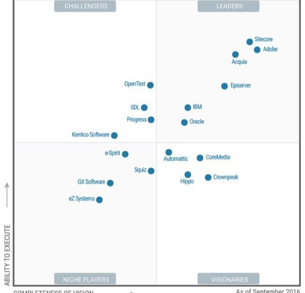
Naturally, I follow them with interest, and am sharing the latest Magic Quadrant here.
This Year, Gartner Research has downgraded OpenText, SDL and HP from the leader’s quadrant in its latest industry report on web content management (WCM).
Previous contenders Sitecore, Adobe, Acquia, EPiServer, IBM and Oracle retained their spots on the leaderboard in the Stamford, Conn.-based research firm’s Magic Quadrant for Web Content Management, which it released yesterday. According to Gartner report authors Mick MacComascaigh and Jim Murphy, Boston-based Acquia made the biggest positive move, closing the gap on Copenhagen-based Sitecore and San Jose, Calif.-based Adobe.3
But Sitecore and Adobe still lead the WCM pack, based on Gartner’s criteria of completeness of vision and ability to execute. It was the same story last year, with Sitecore edging Adobe for execution but Adobe winning in the vision department, Gartner concluded.
Acquia, a Drupal-based, open source content management system, jumped from a visionary to a leader in 2014 and hasn’t left the leaders’ spot since. It’s the lone open source vendor among the leaders.
Microsoft, rated a niche player last year, failed to make the cut this year. MacComascaigh and Murphy said Microsoft has focused its attention more on the digital workplace and less on WCM.
It places them in one of four quadrants:
Leaders: Those who “drive market transformation” and are “prepared for the future with a clear vision and a thorough appreciation of the broader context of digital business.”
Challengers: Those who may have a strong WCM product but have a product strategy that “does not fully reflect market trends.”
Visionaries: Those that are “forward-thinking and technically focused” but need to improve and execute better.
Niche Players: Those who focus on a particular segment of the market, such as size, industry and project complexity. But that, according to Gartner authors, “can affect their ability to outperform their competitors or to be more innovative.”
Gartner Magic Quadrant for WCMS – 2016
Hope you found this article useful.
GitHub will release as open source the GitHub Load Balancer (GLB), its internally developed load balancer.
GLB was originally built to accommodate GitHub’s need to serve billions of HTTP, Git, and SSH connections daily. Now the company will release components of GLB via open source, and it will share design details. This is seen as a major step in building scalable infrastructure using commodity hardware. for more details please refer to the GitHub Engineering Post .
GE & Bosch to leverage open source to deliver IoT tools
Partnerships that could shape the internet of things for years are being forged just as enterprises fit IoT into their long-term plans. Representation of an IoT & IIoT Convergence
As a vast majority of organisations have included #IoT as part of their strategic plans for the next two to three years. No single vendor can meet the diverse #IoT needs of all customers, so they’re joining forces and also trying to foster broader ecosystems. General Electric and Bosch did both recently announced their intention to do the same.
The two companies, both big players in #IIoT, said they will establish a core IoT software stack based on open-source software. They plan to integrate parts of GE’s #Predix operating system with the #Bosch IoT Suite in ways that will make complementary software services from each available on the other.
The work will take place in several existing open-source projects under the #Eclipse Foundation. These projects are creating code for things like messaging, user authentication, access control and device descriptions. Through the Eclipse projects, other vendors also will be able to create software services that are compatible with Predix and Bosch IoT Suite, said Greg Petroff, executive director of platform evangelism at GE Software.
If enterprises can draw on a broader set of software components that work together, they may look into doing things with IoT that they would not have considered otherwise, he said. These could include linking IoT data to ERP or changing their business model from one-time sales to subscriptions.
GE and Bosch will keep the core parts of Predix and IoT Suite unique and closed, Petroff said. In the case of Predix, for example, that includes security components. The open-source IoT stack will handle fundamental functions like messaging and how to connect to IoT data.
Partnerships and open-source software both are playing important roles in how IoT takes shape amid expectations of rapid growth in demand that vendors want to be able to serve. Recently, IBM joined with Cisco Systems to make elements of its Watson analytics available on Cisco IoT edge computing devices. Many of the common tools and specifications designed to make different IoT devices work together are being developed in an open-source context.
DCNS's Scorpene Data Leak and Future of Indian Submarine Fleet
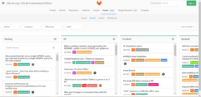
The startup today introduced an issue tracking feature for its fast-growing code hosting platform that promises to help development teams organize the features, enhancements and other items on their to-do lists more effectively.
The GitLab Issue Board is a sleek graphical panel that provides the ability to display tasks as digital note cards and sort them into neat columns each representing a different part of the application lifecycle. By default, new panels start only with a “Backlog” section for items still in the queue and a “Done” list that shows completed tasks, but users are able to easily add more tabs if necessary. GitLab says that the tool makes it possible to break up a view into as many as 10 different segments if need be, which should be enough for even the most complex software projects.
An enterprise development team working on an internal client-server service, for instance, could create separate sections to hold backend tasks, issues related to the workload’s desktop client and user experience bugs. Users with such crowded boards can also take advantage of GitLab’s built in tagging mechanism to label each item with color-coded tags denoting its purpose. The feature not only helps quickly make sense of the cards on a given board but also makes it easier to find specific items in the process. When an engineer wants to check if there are new bug fix requests concerning their part of a project, they can simply filter the board view based on the appropriate tags.
Google this week has published a new version of its TensorFlow machine learning software that adds support for iOS. Google initially teased that it was working on iOS support for TensorFlow last November, but said it was unable to give a timeline. An early version of TensorFlow version 0.9 was released yesterday on GitHub, however, and it brings iOS support.
For those unfamiliar, TensorFlow is Google’s incredibly powerful artificial intelligence software that powers many of Google’s services and initiatives, including AlphaGo. Google describes TensorFlow as “neural network” software that processes data in a way that’s similar how our brain cells process data (via CNET).
With Google adding iOS support to TensorFlow, apps will be able to integrate the smarter neural network capabilities into their apps, ultimately making them considerably smarter and capable.
At this point, it’s unclear when the final version of TensorFlow 0.9 will be released, but the early pre-release version is available now on GitHub. In the release notes, Google points out that because TensorFlow is now open source, 46 people from outside the company contributed to TensorFlow version 0.9.
In addition to adding support for iOS, TensorFlow 0.9 adds a handful of other new features and improvements, as well as plenty of smaller bug fixes and performance enhancements. You can read the full change log below and access TensorFlow on GitHub.
Major Features and Improvements
Python 3.5 support and binaries
Added iOS support
Added support for processing on GPUs on MacOS
Added makefile for better cross-platform build support (C API only)
fp16 support for many ops
Higher level functionality in contrib.{layers,losses,metrics,learn}
More features to Tensorboard
Improved support for string embedding and sparse features
TensorBoard now has an Audio Dashboard, with associated audio summaries.
Big Fixes and Other Changes
Turned on CuDNN Autotune.
Added support for using third-party Python optimization algorithms (contrib.opt).
Google Cloud Storage filesystem support.
HDF5 support
Add support for 3d convolutions and pooling.
Update gRPC release to 0.14.
Eigen version upgrade.
Switch to eigen thread pool
tf.nn.moments() now accepts a shift argument. Shifting by a good estimate of the mean improves numerical stability. Also changes the behavior of the shift argument to tf.nn.sufficient_statistics().
Performance improvements
Many bugfixes
Many documentation fixes
TensorBoard fixes: graphs with only one data point, Nan values, reload button and auto-reload, tooltips in scalar charts, run filtering, stable colors
Tensorboard graph visualizer now supports run metadata. Clicking on nodes while viewing a stats for a particular run will show runtime statistics, such as memory or compute usage. Unused nodes will be faded out.